Skip to content

Remote ID For Manned Aviators

While commitments have been made to leverage industry support on technical implementations, there remains a need to address how Remote Identification (RID) can support existing low altitude airspace operations. RID information should be something that all low altitude aviators can take advantage of to improve safety – whether it is for emergency medical helicopters, public safety, crop dusters, or any other general aviation pilot. Last year Hidden Level published a white paper on the gaps that remain with RID previous to the notice of proposed rulemaking (NPRM) being published for comment. Our paper, “Realizing Remote ID“, included highlighting operational issues ahead for Cockpit Awareness for low-altitude pilots and for Coverage/Flexibility of RID information delivery risk mitigation.

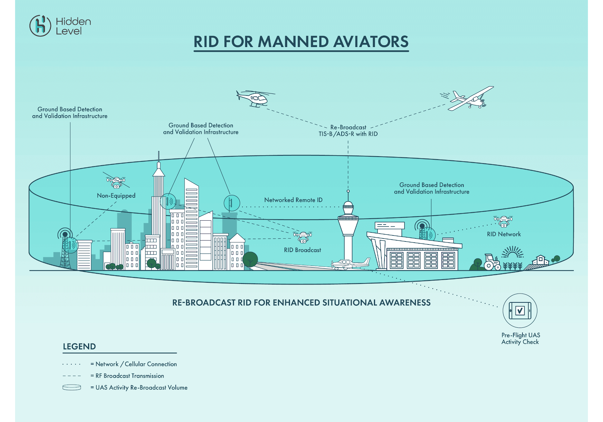
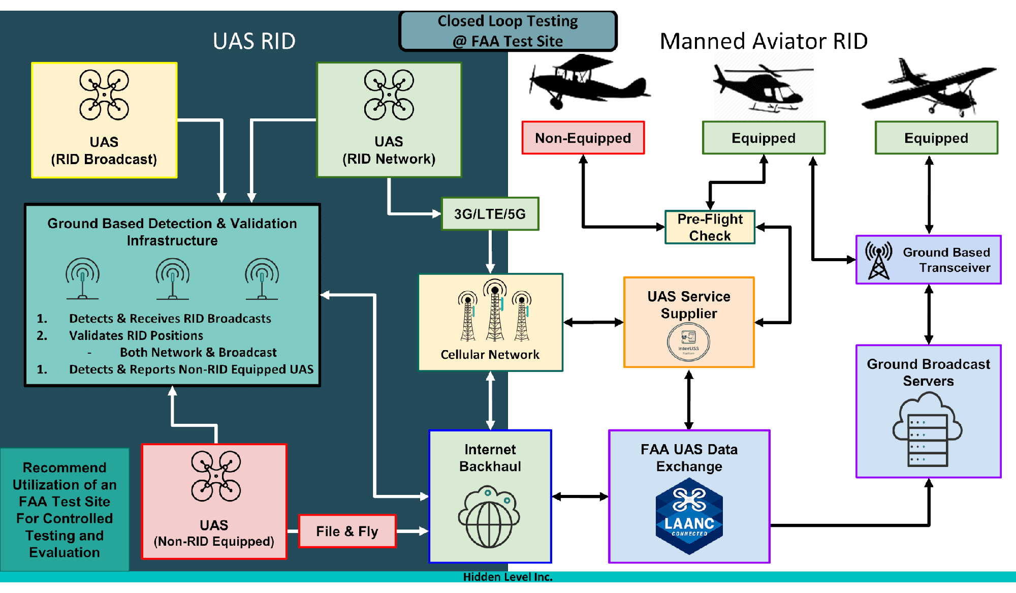
Thankfully the FAA released an RFI related to the Cockpit Awareness gap in March of 2020, looking for ways in which manned aircraft can receive and use the network or broadcast UAS RID information. Hidden Level hopes that this will lead to some R&D and testing to look at a variety of solutions to close this gap in the near future. In the meantime, Hidden Level looks to share its perspective on some viable methodology in which to test sharing of RID information for Cockpit Awareness.

4 Key Factors For Consideration

Hidden Level believes there are 4 important factors that should be addressed with any comprehensive solution to supply RID to manned aviators.

  1. Provide Flexibility In Access To RID Information For Manned Aviators

    1. Make accessible through multiple avenues
      1. Existing avionics equipment, FAA infrastructure, and procedures
      2. Existing manned aviator pre-flight planning tools
      3. Existing UAS Traffic Management tools such as UAS Service Suppliers
  2. Ability To Handle Awareness of Multiple UAS Types

    1. RID Equipped UAS – Broadcast
    2. RID Equipped UAS – Network
    3. Non-Equipped UAS
      1. Non-cooperative or nefarious operations
      2. Pre-approved flight operations, such as File and Fly recreational flyers
  3. Ability To Verify and Validate Reported RID Information

    1. Determine if RID information is real, spoofed, or non-compliant
    2. Report anomalies with UAS flight
      1. Ex. Inaccuracy of reported GPS position
  4. Demonstrate Viability Under Representative Closed Loop Testing

    1. Utilize FAA test sites to exercise concept(s) with industry collaborators and FAA supported resources

How can we test sharing RID information?

The graphic above entitled “RID For Manned Aviators” depicts a conceptual look at sharing RID information with manned aviators by utilizing existing FAA infrastructure, sharing data with the UTM ecosystem, and using existing avionics and flight tools.

Utilize Existing Air Traffic Infrastructure

  • Re-broadcast UAS track data or activity zones via TIS-B/ADS-R
  • Supplemental ground based infrastructure can stream data into FAA data distribution cabinets for SBS network
  • Increase range and coverage of RID information to manned aviators

Push Ground Based Sensor Data To UAS Service Suppliers

  • Supplement known cooperative data with validation
  • Track non-cooperative flights
  • Share information on web/tablet/cell based apps

Empower Pilots Using Their Existing Avionics and Flight Tools

  • Share data with pre-flight planning tools (ex. ForeFlight, Garmin Pilot)
  • Remove barrier to entry for manned aviators
  • Enable already in-use equipment such as 978/1090 transceivers, cockpit displays, and audio warning systems

What are some challenges with testing this kind of approach?

The graphic above, entitled “Closed Loop Testing” depicts a conceptual integration and test mapping of a RID For Manned Aviators concept. With closed loop testing of viable solutions we can start to provide some practical data points and feedback on overcoming some of the challenges that may arise from implementation.

Scalability

  • Areas of high criticality, urban centers, airports, airfields should be first targets for maximum initial impact with a validation and re-broadcast scheme
  • Areas that may not have ability for extra infrastructure support would need to rely on pre-flight check and planning concepts

Providing information on UAS not using RID

  • Increases importance of utilizing ground based sensor infrastructure to report all types of UAS activity

Supplying data to cockpit without pilot overload

  • Need for selective RID re-broadcast volume priority rules

Interoperability of UAS Service Suppliers

Closing Thoughts

Putting some of the concepts shared here to test (along with other suggested innovative solutions) with collaboration from industry and the FAA in a closed loop environment could produce valuable insights to help try to close the gap of Cockpit Awareness and RID.

The advancement of Remote ID technology can help both drone integration and drone security issues as long as operational concepts such as sharing RID with manned aviators is matured along the way. Hidden Level has always taken interest into the advancements in technology related to UAS Traffic Management and the safety of low altitude operations. Enabling a cooperative airspace, with the least amount of classification challenges will unlock the ability to increase future density of low altitude aircraft operations while simultaneously reducing collision risks.

James Licata
VP of Strategy and Partnerships
james.licata@hiddenlevel.com

Questions or feedback?

If you have thoughts, suggestions, or insights about this topic please let us know!